Stretching over 200 miles from north to south, R11E is a thin and unremarkable strip of land, covered, like most of Illinois, with soybeans and corn. On closer inspection R11E turns out to be an anomaly, noteworthy for what failed to happen within its sharply delineated borders. It is where two survey crews, working from opposite directions in the early part of the nineteenth century - one moving west from the Second Principal Meridian in Indiana and the other moving east from the Third Principal Meridian in central Illinois - failed to meet. Rather than re-survey, which would have temporarily slowed the tide of speculation and settlement, the crews simply connected the dots and proceeded westward....
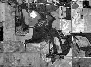
Today the strip is characterized by odd angles and irregular distances. The township sections that comprise R11E, usually one square mile, are neither square nor one mile. From the air the disruption of the grid is conspicuous. In an otherwise well ordered landscape R11E is a small yet significant fissure in an overarching grid that blankets two-thirds of the United States.
I am interested in the symbolic potential of R11E. If the grid orders and controls space then what can be made of the places where the grid fails? "Circumambulating R11E" is simply the act of calling attention to the potential of this space by walking each of the 35 "square miles" of R11E within Champaign County. Differentiating a monotonous landscape in this manner offers points of entry into thorny questions that operate over and through a vast expanse of space and time - it invariably leads to important questions about the production of space and how the ordering of the land constitutes and orders subjects (and vise versa). For more on this idea check out a recent essay by the geographer Nicholas Blomley: "Law, Property, and the Geography of Violence: The Frontier, the Survey, and the Grid."
A more ambitious intervention might entail a large scale prairie restoration - allowing the dominant pre-1800 ecosystem to reassert itself. Imagine a monumental strip of tallgrass prairie two hundred miles long by one mile wide, visible from space along with the Fresh Kills Landfill and the Great Wall of China....
May 20, 1785, is a momentous day in United States history. On that day Congress authorized the surveying of the western territories into six-mile-square townships. Each township, Congress directed, would be bounded by lines running due north-south and east-west; other parallel lines would divide each township into thirty-six square sections of 640 acres each. The Land Ordinance of 1785 began in compromises that truly satisfied no one, but with minor revisions it determined the spatial organization of two-thirds of the present United States. The Ohio farmer of 1820 - and much later the Wyoming rancher and the California fruit grower - settled and shaped wilderness surveyed according to the traditional and Enlightenment optimism that translated the urban grid of Philadelphia onto land destined for agriculture.
Common Landscape of America, 1580 to 1845 (1982)
John Stilgoe
We inherit a grid that is simultaneously real and metaphorical. It has shaped materially our system of land use and our way of thinking about land - about the natural, the wild, the humanized, the civilized. It holds our memories and our lives and our plans. At the same time, it signifies our adherence to, and the imposition of, an abstract construction of the human mind. We have looked to the lines first, not to the land upon which the lines were laid. In this light, we can see that one of the functions of an evolving land ethic is to help us now to read in between - and across - the lines.
Correction Lines: Essays on Land, Leopold, and Conservation (2004)
Curt Meine
Despite these improvements, Mansfield's surveyors were not immune from error. Massive jogs occurred in eastern Illinois, where the parallels running out from the Second Principal Meridian spectacularly failed to meet up with those of the Third Principal Meridian, and a "shatter zone" of steeply angled lines had to be introduced to join one lot to the other. But such mistakes were inevitable given the pressure the surveyors were under to make land available for sale as quickly as possible.
Measuring American (2002)
Andro Linklater
Two separate parties surveyed the county. In 1821, the eastern townships were measured and marked, and the following year, the western divisions were completed. The task was both difficult and hazardous, so it is not surprising that the two crews did not come out even. A narrow strip, Range 11 East, appears as an irregularity between the two surveys. One story is that strips of rawhide were used to measure distances, and rawhide has an unhappy habit of stretching or contracting, depending upon moisture and heat.
Cornsilk and Chaff of Champaign County (1969)
Richard L Morgan